|
COMENIUS PROJECT TITLE:
“RIVERS, THE ARTERIES OF THE EARTH”
Co-ordinator: Dr. D. Kalaitzidis
FIELD WORK AT SPERCHIOS RIVER
Environmental Education Group: Katherine
Apostolopoulou, Efi Argiri, Chrysa Arzoumanidi, Theodosia
Vardalakou, Mary Diakaki, Rania Zerikioti, Spyridoula Kokaki, Mary
Konstantakou, Eyangelia Makariadou, Helen Banda, Demetra Basta,
Eyangelia Xifara, Despina Orestidou, Ioanna Paraskeva, Maria-Helen
Sideri, Ioanna Tzafalia, Evi Tziola, Anthi Tsekoura, Nefeli
Tziveleka, Elisavet Tsilali, Chrysa Frangiadaki, Vasiliki Peraki,
Mary Xirakia, Sofia Spentzou, Natasa Agalioti, Anna Drosou,
Katherine Zamblakou, Anastasia Karamitsiani, Sofia Karamitsiani,
Chrysa Kavga, Katherine Kypreou, Evi Marolia, Amalia Ornithopoulou,
Meropi Panagiotarakou, Nina Panagiotidou, Argyro Frangiadaki.
Text Translation by: Nina Panagiotidou,
Nefeli Bardani, Nikitia Mexia, Natasa Bia, Maria Koutsandrea.
Translation supervisor: Evangelina
Vavouraki
On Saturday the twelfth of November 2000, our
environmental education team set off for its educational excursion
to the river Sperchios.
This river lies in the prefecture of Fthiodida
not far away from the city of Lamia. Its name comes from the verb
“spercho” that means flow rapidly. Its headwater is in the
mountains of Evrytania (Tymfristos) and it runs across the Lamia
plain, moving eastwards and enters Maliakos Bay. It is 82 Km long
and it collects 12 tributaries that flow from the mountains Oiti
and Othrys. From its waters a great part of Lamia’s plain (which
is considered as one of the most fertile plains of our country) is
irrigated.
|
 |
|
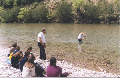
Photo: Discharge
measurement on rive Evinos |
While our teachers Mr. D. Kalaitzidis, P.
Pefanis, S. Panaretos and Mrs. K. Panagou taking the lead, we set
off from our school by bus early in the morning.
We had already prepared for all the activities
concerning our project so that everyone should take action from
the very beginning. Besides, we were supplied with a list of data
for filling in our remarks or questions. We divided into five sub-groups
in order to make our job easier and have the opportunity to
participate actively.
At the first point of the river where we stopped
having with us Mr. Vangelis Markatselis, a geologist from the
Environmental Education Center of Ypati- Stylida, we could not get
near the riverbanks as they were very steep and covered with
vegetation. So we did not walk up there for the fear of falling
down.
On the contrary, the second point where we
finally stopped was quite flat with the riverbed being over fifty
meters wide. Also there was a relatively new concrete bridge and
the river banks nearby were covered with boulders put in boxes of
thick wire (we were told that they are called “sarazanet”). The
stones were there for the protection of the banks from erosion,
which might cause the collapse of the bridge. A bit farther down
at the riverside there was a sheep-fold with sheep and dogs
watching over.
As soon as they saw us, a swarm of children, the
sheep started running away while the dogs barking. It was a little
difficult for us to get down from “sarazanet” into the riverbed.
However, we made it. When we got down, we divided into parties and
started working.
|
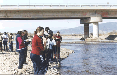 |
|
Photo: Discharge
measurement on river Sperchios |
The party who had to measure the quality of the
water with the portable chemistry lab, sat near the water and
started working. With the help of Mr. Pefanis and Mr. Kalaitzidis
we did the measuring for nitrates and nitrites, PH value and
diluted oxygen. We found the nitrates to be under 10 mg/L which
means that the quality of the water is good. We found the nitrites
to be 0,2 mg/L indicating good water quality. The PH value was
just as good as 7,2, indicating fine water quality. The measuring
showed that the water was clear and of course because of the
winter rain, the chemical substances are dissolved in a great
amount of water and it is natural for the concentration of
nitrates and nitrites to be low. In addition, the fertilizers
could go downstream to the river. The River flow measuring party
with the help of Mr. Panaretos, measured firstly the width of the
river using a technique first found by the scouts, namely a wooden
pole with a wooden stick screwed on the top. When someone stands
at one riverbank looking at the other, fixes properly the angle of
the stick. Then turning 90 degrees, on the riverbank where he
stands, then he can determine and find the width of the river
without getting his feet wet. At that point we fount that the
river was 6,60m wide.
After that, by using the pole, we measured the
depth of the river at the measurement point and on the width line
and we found three different results at three different points: 19
cm, 29 cm, 50 cm. Then using a sheet of milimetre paper we
calculated the surface of the river cross section at that point.
So, we found that that the river was 2,16 sq.m. in area.
Then we laid down 20 meters of the riverbank
where we were standing and with the aid of the chronometers we
calculated how much time it took for a tennis ball to cover those
20 m. floating on the surface of the river waters. The speed of
the river water was different at different points on the width
line of the river. Near the bank the duration was 60 sec, in the
middle of the current was 19 sec, and it was 15 sec near the
opposite bank. The average water speed was about 0.82 m/sec.
Afterwards, by using the formula P=SXU (P= Discharge, S= surface
of the cross section, U=water speed) we found it was 1,8 cubic
meters per second. Another calculation showed 0,96 c.m/sec. Of
course, there is a considerable difference between these two
estimations, but what really matters is the procedure more than
the outcome, as our teacher told us.
|
 |
|
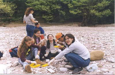
Photo: Estimation of the
river wter quality, using thi macrobiotic Index |
The group, which measures the river’s
characteristics, recorded certain species of the flora,
principally trees (plane trees, poplars, willows) and certain
species of animals that we observed. Surely, we didn’t see any
wild animals, since we were in inhabited areas. The mild animals
we saw were sheep, goats and domesticated animals, such as cats,
dogs, and chickens. Mr. Markatselis told us that many birds take
to the river trees to build their nests. The riverbanks were in
some places verdant, while in other ones almost bare. As we have
already mentioned. Some parts had paving with cement. The trees
that we mostly saw in the banks were big plane trees, which had
started losing their leaves as autumn was finishing, willows –
water willows, poplars and other kinds of trees and plants that
need great amounts of water.
A team engaged in the uses of water could not
locate pumping units in the river, because during winter
cultivation is not irrigated. Nonetheless, near the village
Paliouri we saw a field being watered with artificial rain for the
seeds to grow fast. Besides we did not see boats, dams (either
hydroelectric or irrigation) because the area, which we visited,
was rather smooth and the vale of the river had great width and in
such areas dams cannot be constructed. However we saw people, a
young man and his father, placing a net vertically in the river in
order to catch fishes. They got into the water wearing big
Wellington boots, that came up to their waist and upwards so they
did not get wet. They fixed the net in the one bank and then in
the other and left with a view to coming back later to collect the
net and the fish. We also saw a large flock of sheep coming to the
river to drink water. Near the river there were many fields. Some
people whom we asked told us that cereals, maize, cotton, clover,
etc. are grown there. Somebody told us that kiwis are grown there
as well and complained that the traders buy them for 50 drachmas
per kilo (0.13 $) while they sell them for 300 (0,8$).
The team, which was responsible for the waste,
located much of this mainly in the banks of the river, where it
was thrown by the unprincipled, polluting both the river and the
environment. Such wastes were vehicle rubbers, wrappers, plastics,
old clothes, paper, metal, etc.
|
 |
|
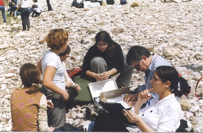
Photo: Calculation of the
river water quality, using he portable chemical lab |
In the village Paliouri where our next stop was,
we passed along a weird and leaning bridge, which was constructed
with cement and iron. The one gatepost which supported it had such
a gradient that the whole bridge leaned. It was a low one and
perhaps old, though not ancient. From that bridge the view of the
river was fascinating. Its banks were covered with plane trees,
which had taken a red- orange color from their leaves, which were
ready to fall. The water was quite calm and rather little. There
we measured the diluted oxygen (D. O.) and found it satisfactory.
Our first visit to the river Sperchios came full
circle in the historic village of Gorgopotamos (Quick-River),
where we stopped to have a meal, before we journeyed back home.
It was an exciting excursion with interesting
fieldwork and we hope to be more experienced and find more things
in our second visit.
|
 |
|
Photo: Student's
(presentation at the Klitoria
Environmental Ecucation Centre) |
SHEET OF DATA RECORD
Date: 12/11/2000
Weather Conditions: During the morning cloudy,
and for the rest of the day sunny
Location: Fthiodida Prefecture/ Sterea Ellada/
Village Paliouri
Name of the River: Sperchios
Origin of the name: the verb spercho=flow
rapidly
Sources: Tympfristos Mountain
Tributaries: 12 (Inarchos, Ksydias, etc)
Estuaries: Maliakos Gulf
Delta: Yes
Length: 80 km
Water quality: Good
Air temperature: 18 degrees
Water temperature: 10 degrees, later 11 degrees
Altitude: 40 m
Distance from estuaries: 25 Km
Water color: colorless
Discharge: 1.7c. m./ sec
Odor: No
Human activities in the basin: Cultivations of
cotton, maize, cereals. Greenhouses
Industries: No
Irrigation: Too early for irrigation
Pumping stations: Yes
Number of pumping stations: A few
Villages along the river: Kostalexi, Meskiates,
Lianokladi
The biggest one: Kostalexi
Mountains surrounding the basin: Othris, Giona,
Velouchi, Tympfristos
Tree species on the banks: Plane tree. Willow,
poplar, silver poplar
Animals and birds: Goats, sheep, cattle, dogs
|